| Period: 18 October 2003 - 31 March 2004. Country: China |
|
(1) Study on Land Use and Resource Management of the Rice-Terrace Agricultural System in the Ailao Mountains, Yunnan, China |
| ADACHI Shinpei (Division of Southeast Asian Area Studies) |
| Key Words: Yunnan, Mountain Agriculture, Terraced Paddy Field, Land Use, Resource Management |
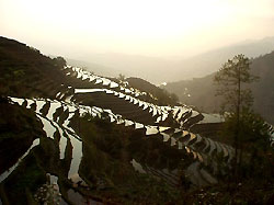
Terraced paddy fields inundated with water in the dry season (winter). |
(2) The Ailao mountains in Yunnan province are famous for its wide landscape of terraced paddy fields. The objective of this study is to clarify land use and resource management in four villages on the slopes of the Ailao Mountains.
(3) The field survey was conducted from December 14, 2003 to February 22, 2004 at four villages on the slopes of the Ailao mountains (village Q: inhabited by the Hani ethnic group, settlement elevation 1820m, village S: Yi, 1650m, Village J: Zhuang, 1070m, village P: Dai, 270m). Brief interviews on land use were held with village leaders and statistical data were collected at local government offices at the villages. The mapping of forests and irrigation ditches by GPS and interviews on resource management was conducted at two villages (Q and S). The main results are as follows.
- Land use varies depending on the elevation. In the higher villages (Q and S), the cultivation of rice in the paddy fields and maize in the upland fields, both for self-consumption, are the dominant land uses, while in the lower villages (J and P), various kinds of cash crops such as sugar cane, cassava and tropical fruit trees are widely cultivated in addition to rice and maize. In villages Q and S, the traditional rice varieties are planted once a year in most rice fields, and the fields are kept inundated during the winter in order to protect dikes. On the other hand, in villages J and P, ratoon cultivation and double cropping with improved rice varieties are widely used in most rice fields and the fields are dried up in order to plant cash crops such as cucumber and water melon during the winter. This difference in land use has affected the livelihood structure in this area. For example, many migrant laborers are observed in villages Q and S, but there are few in villages J and P.
- Forest management varies among the villages. Villages Q and S have community forests managed by the villagers collectively, while in villages J and P, community forests are allocated to individual families and managed by them. Many farmers in villages J and P have changed their forest land into fruit orchards.
- For all the villages, irrigation water is taken from springs or small streams in the mountains, but there are differences in the pattern of irrigation ditch distribution among the villages. For example, in village Q, most of the irrigation water is taken from the mountain just behind the village settlement, but in village S, the water is taken from a stream far from the village through a long irrigation channel (about 7km in length). Village Q has a unique way of fertilizer application, called "chong fei." In the winter, manure stored near the houses is transported into each house's paddy fields 200-300m below the village settlement in altitude, using the water in the irrigation channels. This technique requires a great deal of water in the dry season, and uses an irrigation system with longitudinal channels that run from the water source down to the paddy fields, passing through the settlement.
These results show that there is great diversity in land use, technology and resource management, depending on altitude and topography among the villages in the Ailao mountains.
|
 21st Century COE Program
-Aiming for COE of Integrated Area Studies-
21st Century COE Program
-Aiming for COE of Integrated Area Studies-