5. "Crawling along the Ground" and "Getting a Bird's-eye View" There is no doubt that the accumulation of small facts and elaborate analysis is crucial for any research. Village studies are indeed research activities that require such steady endeavors. Still, it is also necessary to carry out research activities under a broader framework, even if they are wanting in preciseness. When I launched the project mentioned at the outset of this chapter, my idea was that a complementary combination of these two approaches might help to raise the level of research a notch. In other words, I intended to conduct research covering the whole area of Northeast Thailand, rather than just a village in the region, in order to grasp major trends, though such an approach might compromise the degree of precision that often depends on specific fact-finding case studies. In a manner of speaking, I wanted to get a bird's-eye view of the ground on which I had been crawling. There are many ways to get a bird's-eye view. They include methods such as aerial photographs and satellite images, approaches for mobilizing many people to gather a large amount of information, such as wide-area crop growth monitoring and questionnaire surveys, and more academic methods for constructing a logic by finding matters and benchmarks that hold the key to the phenomenon to be studied. Since the project is the first such attempt, we are experimenting with a variety of methods.
KONO Yasuyuki |
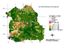 This
chart shows the yield distribution for rain-fed paddies in rainy-season cropping
for the whole of Northeast Thailand in 1997. The MAPNET project and the Northeast
Regional Office of the Department of Agricultural Extension conducted a joint
questionnaire survey in collaboration with agricultural extension officers
of the whole regionists. The chart is a GIS display of the survey results.
In the southwestern part of the region, yields failed to reach one ton per
hectare due to drought.
This
chart shows the yield distribution for rain-fed paddies in rainy-season cropping
for the whole of Northeast Thailand in 1997. The MAPNET project and the Northeast
Regional Office of the Department of Agricultural Extension conducted a joint
questionnaire survey in collaboration with agricultural extension officers
of the whole regionists. The chart is a GIS display of the survey results.
In the southwestern part of the region, yields failed to reach one ton per
hectare due to drought.