|
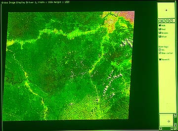
13. Satellite Image 1 Satellite images of the Ituri forest help us to fairly clearly grasp the traces people have left in the forest. The picture shows an image of the eastern part of the Ituri forest. The greener the color, the deeper the forest. White lines are roads. The yellow portions along the roads are either fields or secondary forests. As one may expect, there is noticeable change in the vegetation along the roads which run through the forest from east to west and north to south. If you look more closely, however, you see within the forest yellowish parts, i.e. secondary forests, here and there. They are traces of human activities, such as old, abandoned settlements and fields.
ICHIKAWA Mitsuo |